Tuesday, 30 October 2012

KANDY TEMPLE OF THE TOOTH

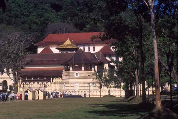
Kandy Temple of the Tooth

                        
Kandy served as the capital of the last Sinhalese kingdom, which fell to the British in 1815 after defying the Portuguese and Dutch for three centuries.
The scenic city of Kandy is 115km inland from Colombo, and 500m above sea level is climatically, culturally and a world away from the urban business of the capital.
The well-known 16th century Temple of the Tooth, also known as Sri Dalada Maligawa
The Temple of the Tooth, or Sri Dalada Maligawa is a temple in the city of Kandy in Sri Lanka. It was built within the royal palace complex ,which houses the only surviving relic of Buddha, which is venerated by Buddhists.                                                                                                                                      
               It is strongly believed that the temple houses the upper canine tooth of the Lord Buddha.


 temple_ of_ tooth_9    Due to changed star configurations, after many years of conducting the Esala Perahera in the months of June or July, this year's procession will revert to its namesake month of Esala (or August).. Prince Danta and Princess Hemamala brought it to Sri Lanka during the Anuradhapura Era from when it became imperative that the King of the Land must be the guardian of the "Dalada".
 Dalada Maligawatemple_ of_ tooth_14

     
       Kandy Temple of the Tooth
      

Sunday, 28 October 2012

SINHARAJA FOREST


 SINHARAJA FOREST

Sinharaja Forest Reserve is considered one of the most important natural habitats in Sri Lanka.
.
From Northern or western parts of the country you can reach Sinharaja Forest Reserve via Ratnapura, Kiriella, Kalawana, Weddala. From the South you can enter Sinharaja Rain Forest from Deniyaya. Coming form Habanthota Udawalawe you can enter Sinharaja from Rakwana side.
                                                                                                                The Sinharaja region has long featured in the legends and lore of the people of Sri Lanka. Its name, literally meaning lion (sinha) king (raja), perhaps refers to the original ‘king-sized or royal forest of the Sinhalese’, a people of the legendary ‘lion-race’ of Sri lanka.
The sinharaja forest is home to many rare animals, birds, butterflies, insects, reptiles and trees. Ferns and mosses grow well as the climate is humid because of heavy rainfall.
The vegetation
Vegetation means trees, shrubs and woody climbers. The average height of trees in the sinharaja varies between 35 to 40 meters. Some trees are above 50 meters.
The animals and the birds.

Sinharaja Forest
                                                                          

Saturday, 27 October 2012

beautifull galle

            GALLE
some believe that there was a very large ‘Gaala’ of cattle here.Gaala in Sinhala means the place where cattle are herded together. So they believe Galle is a development from ‘Gaala’.
Galle is located 116 kilometer to the south of Colombo and was founded by Portuguese.


galle city in main schools

  1. Sangamiththa girls college                          
  2. Richmand collage
  3. Vidyaloka collage
  4. Mahinda collage
  5. St,aloysius
  6. Siridamma collage
  7. Rippon girls collage
  8. Olcott vidyalaya                                                                          
  9. Anula vidyalaya
  10. Sudarma Vidyalaya.
  11. Southland girls collage           
       
galle is agricultural market center,export tea,rubber,coconut oil ,clovea &  other products of the surrounding regin.exports tea, rubber, coconut oil, cloves, and other products of the surrounding region.                                                        This place is gall roundabout.                                                                                                                                                                                                                                                    


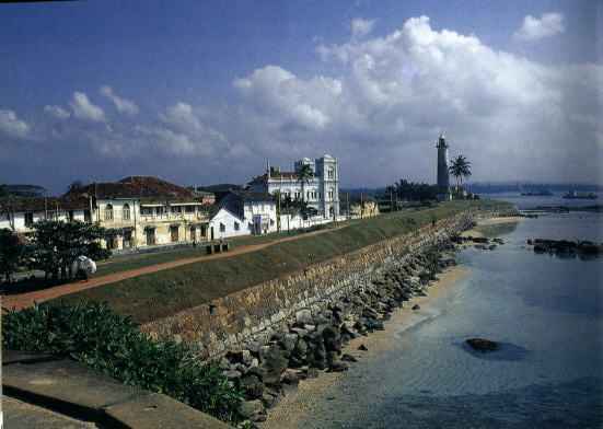
  •                                                          This place is gall light house

    http://www.srilankatravel.de/photogal37/1847galle.jpg
    http://www.srilankatravel.de/photogal37/1854galle.jpg                      

                                            Galle fish market & fruit market.
               http://www.srilankatravel.de/photogal37/1859galle.jpg   
      Apa Villa Thalpe  
     Galle dutch fort
    1.    Portuguese built the first fort to withstand attack from the Sri Lankan kingdoms to the north. Dutch who captured the coastal cities from the Portuguese improved the defence system of the fort, widening the moat on the landside, improving the ramparts and the bastions. British who captured the city did not make many changes as they shifted the part to the northern town of Colombo and therefore the atmosphere of Dutch days are preserved to date. The Dutch entrance to the fort with it VOC with 1669 carved in the inner archway is still in use. Still there are many old Dutch buildings intact and, but unfortunately except for those in the private hands. The ramparts and the bastions still bring to life the old world.
    2.                  
    3.          To And From Galle
    4.                    Distance to other Towns in Km
    1. Colombo 116
      Matara 45
      Ratnapura 150
      Benthota 32
      Thissamaharama 146
      Sinharaja 90
         

Friday, 26 October 2012

BAMBARAKANDA WATERFALL

               BAMBARAKANDA WATERFALL
Travel to this place is not easy than other waterfalls of Sri Lanka because this fall is far away from amin road. Kalupahana Junction (160Km from Colombo - Badulla road) is closest main road to Falls. Kalupahana is at Between Belihul Oya and Haputale. Belihul Oya also famous and beautiful place in Sri Lanka. The distance between Kalupahana snd the waterfall is about 5 kilometers. This 5 Km is wide way and Car, Van or lite vehicle can be travel. The way to Bambarakanda from Kalupahana is not finished at Waterfall. It moves till Ohiya and Horton Plains via Udaveriya tea Estate. About 18Km to Ohiya from Bambarakanda waterfalls.


sri_lanka_waterfall.jpg
  
                                                                                          
Bambarakanda is the789 feet in height. It is however, a wet season fall. A glorious spectacle from October to March when heavy rains turn it in to an impressive, unbroken deluge. The main access to the falls is along a minor but mortable road via Haputale and Kalupahana.Kalupahana is 22 km from Balangoda or 32 km from Wellawaya.from kalupahana proceeding 3 km along a narrow road through Weerakoongama you come to the gorgeous waterfall.

Saturday, 20 October 2012

Hummanaya

hummanaya is in thissamaharamaya.from colombo Passing the Matara town & after Dickwella,  turn right at Kudawella and proceed about 1.1 kmbetween thangalla & dikwalla. Residents in the area offer to take care of your vehicle at a nominal fee.We go to walk last stretch .It’s narrow, rugged footpath.From distance you can here the booming sound & have a rock opening at the rock of the top.The sea comes from below ,though the rock.the entire area gets filled with the sound.
                                                                                             Blow Hole, Hummanaya, Southern Province, Sri Lanka (www.secretlanka.com)
You will marvel at this nature’s gift .


Friday, 19 October 2012

dunhinda waterfall


  1. DUNHINDA WATERFALLS
dunhinda is most beautiful waterfalls in sri lanka.waterfall located about 5km from badulla.dunhinda name from the smoky dew drops spray.the best time to see dunhinda june & july.dunhinda is good spot go to trip.the largest being no less dan 263 meters hight..

waterfalls in sri lanka 2

           WATER FALL

 Bambarakanda Falls
bamarakanda is highest  waterfall in Sri Lanka &.  situated in the Badulla District in Belihul Oya.
Water comes to bambarakanda from Horton plains and after goes to Samanala wawa.  After via Valawe river this water go to the see.

Dunhinda Falls

the most populer waterfall is Dunhinda   Sri Lanka. 5 km off Badulla town The waterfall.,its name from the smoky dew drops spray, (dun in Sinhala means mist or smoke) which surrounds the area at the foot of the waterfall. The waterfall is created by the river called Badulu Oya which goes through the Badulla town.dunhinda water started with uma oya.hal oya & samall riwers.


Hunas Falls

this Falls is located in Matale District in  Elkaduwa Village. Apart from the main fall several water streams can be seen during the rainy season. Many tourists visit this fall due to its proximity to both, Hunas Falls & Hunas Falls Hotel. There are two routes to the Hunas Falls. One is coming from Matale to Elkaduwa. The other is Watthegama to Elkaduwa.


Ravana Falls

Situated in the Ella-Wellawaya Road, this beautiful waterfall lies visible from the main road itself. The water rushing down over several steps adds more hues to its sublime beauty. The main drop, however, is 30 ft. in height. It derives its name from the mythical King Ravana of the great Indian epic The Ramayana.


Bopath Ella Falls

Just 15 kms from the Colombo-Rathnapura Road, it falls from a height of 100ft into the Kuru Ganga. The formation itself is a rare beauty with a perfectly heart shaped head, resembling the leaf of the Sacred Bo Tree, hence the name Bopath. Also a popular picnic spot, it is bound to take your breath away.


St. Clare’s Falls

St. Clare’s Falls is 80m in height and at 50m wide, and consists of two segments, known as 'Big St. Clare' and 'Small St. Clare'. Created by the Kothmale River, a tributary of the Mahaweli River, it flows down a slope through an abandoned tea estate  in the Nuwara Eliya District. The fall is located 1.5km from Talawakelle.


Devon Falls

This 280 ft high eye catcher is best sighted from the 20th Milepost on the Talawakelle-Nawalapitiya Road.


Ramboda Falls

It is situated in Pussellawa area. The fall is located 1.6km from the highway. It is near Pussellawa Rest House.


Diyaluma Falls

This is the third highest (171 m) waterfall in Sri Lanka. The fall is located along the Koslanda - Wellawaya Road in the Badulla District. Koslanda is the nearest town to the Diyaluma Falls.


Kirindi Ella Falls

This waterfall belongs to Rathnapura District. The height of this waterfall is 117 metres. Kirindi Ella Falls starts from Kuttapitiya mountain. This is created by Kirindi Oya. At the base of the fall, the water plunges into a deep pool called Diyagathwala. 
      Garandi ella   
  Between Pusselawa and Ramboda there are several waterfalls can be seen. Gerandi Fall situated in Nuwara Eliya district and visible from Gampola to Nuwara Eliya road.

Helboda fall
    Between Pusselawa and Ramboda there are several waterfalls can be seen. Gerandi Fall situated in Nuwara Eliya district and visible from Gampola to Nuwara Eliya road.
                             
                                                    Diyaluma Waterfalls of Sri Lanka
                    Bambarakanda Waterfalls